Part 1 - Australia and the South Pacific Islands
Darwin is the capital of Australia’s Northern Territory and one of the country’s most distinctive cities—tropical, multicultural, and closely connected to nature and Indigenous culture. Small by Australian standards its population is 150,000.
Darwin holds the distinction of being a city that has been largely rebuilt over the past 100 years. In 1942, the Japanese naval force that destroyed Pearl Harbor was the same force that killed Darwin. According to records, more than twice the number of bombs were dropped on Darwin than on Pearl Harbor. But Darwin recovered and rebuilt until Cyclone Tracy destroyed it again in 1974. So, as you're traveling around Darwin, there aren't any buildings or structures older than 50 years old. I'll tell you more about Cyclone Tracy in a bit. Here's where we parked at the Port of Darwin with the city in the background.

While we did have an opportunity to walk around the waterfront district that had shops, restaurants, and a public swimming lagoon, the highlight of Darwin, for us, was the Museum and Art Gallery of the Northern Territory. The museum included a Cyclone Tracy exhibit, Indigenous art, nature exhibits, and a special exhibit of Sweetheart, the famous saltwater crocodile. From top to bottom, left to right - aboriginal art, huge termite mound, the story of Cyclone Tracy, statistics on Cyclone Tracy, examples of Tracy's destruction, the infamous Sweetheart saltwater crocodile, photos of its capture, the Sweetheart "story" and its statistics.


Cairns - is pronounced “Kanz” (sounds like cans), not “care-ns.” Population of 170,000 and gateway to the Great Barrier Reef.
In Cairns, we sorta felt like we were back in Florida. Its very tropical and tourist-friendly. The first day was very exciting because Kathie had arranged a line dancing meet and greet with a group of women from the city. We were very fortunate to have a great venue for the event in that there was a craft brewery 2 minutes away from where are ship was parked. So for 3 hours on Saturday afternoon, a great time of dancing (and for me, beer drinking) was had by all. Here are just a few pictures. If you want more reach out to Kathie.


Actually, before the "big" event, we had an opportunity in the morning to preview some of the sights in the city, which were relatively close to our pier. From top to bottom, left to right - Public saltwater lagoon, flock of pelicans enjoying the water, seaside promenade they call the Esplanade, Olympic torch plaque commemorating the longest Olympic torch up to 1956 (2855 miles), WWI memorial, exterior of modern Catholic Cathedral, interior and stain glass windows of the Cathedral, Bishop's house and my personal favorite - Jimmys.


We had another great day in port on our second day. After catching a local bus, we headed toward the Cairns Botanic Gardens. For all of you flower, plant, tree lovers and bird lovers, it was a veritable paradise of colors. I won't try to name them all, so sit back and enjoy.


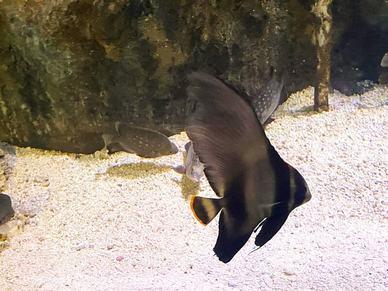
Our third and final day in port was a short walk to a fabulous Aquarium. It had both a freshwater and a saltwater section. The saltwater section is dedicated to reef fish native to the Great Barrier Reef. Once again, I won't bore you with naming them all but enjoy another riot of colors.


The Solomon Islands are a beautiful, less-touristed nation in the South Pacific, east of Papua New Guinea and northeast of Australia. The capital is Honiara the total population is 700,000.
The country is made up of 900+ islands, many mountainous and covered in dense rainforest, with coral reefs surrounding much of the coastline. It has World-Class Marine Life with exceptional snorkeling and diving, often right from shore. Kathie did some snorkeling at Million Dollar point that was famous for being the dumping spot of WWII equipment such as tanks, trucks and jeeps. But first here's a few pictures about the indigenous culture of the islands.


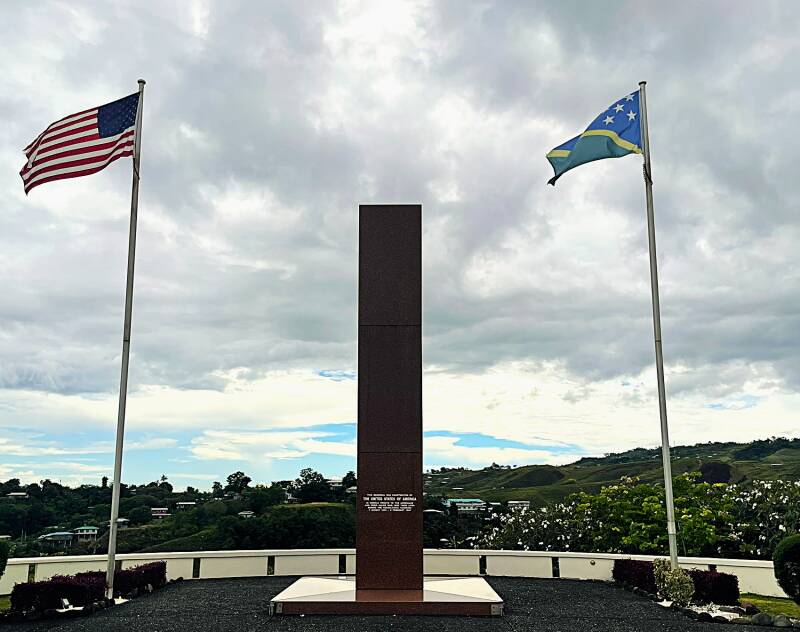
The Solomon Islands, especially Guadalcanal island, was central to Allies winning World War II in the Pacific. Kathie and I took a day while in Honiara to hike up to the Guadalcanal Memorial...it was worth the uphill effort. The memorial was constructed using large marble slabs, each of which, told one of the many stories about the fighting that went on in the area. From top to bottom, left to right - Memorial statue, Memorial plaque, View of Honiara and Iron Bottom Sound, Marble Slabs explaining Guadalcanal Campaign, US Military units involved, Japanese naval vessels destroyed, and the Guadalcanal Naval Battle.


Vanuatu (pronounced vah-noo-AH-too) is a beautiful island nation in the South Pacific, east of Australia and northeast of New Caledonia. It’s made up of about 83 islands, many of them volcanic, lush, and relatively undeveloped. Population approx 330,000.
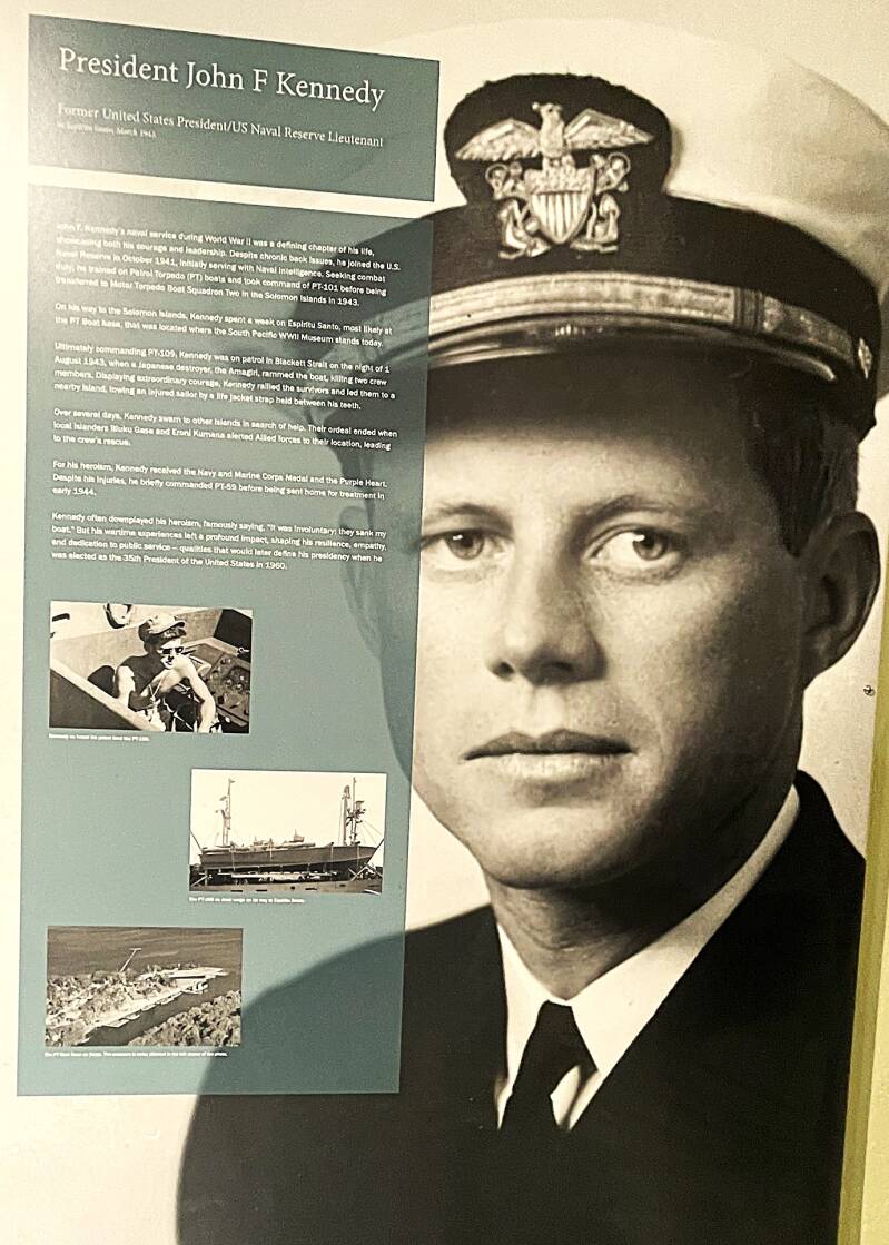
This was a relatively short stop of five days, three on the largest island, Espiritu Santo, in the port of Luganville, one day in the capital of Port Vila, and one day on Mystery Island. Let's start with the Welcoming performers in Luganville, then a visit to a World War II museum. In the museum, they had very interesting artifacts, pictures, and stories. From top to bottom, left to right - pictures and story of Pappy Boyington, WWII hero aviator, picture story of John F Kennedy, picture story of Gene Roddenberry, Star Trek creator, picture and recovered steam whistle of SS Calvin Coolidge, a converted cruise ship that became a personnel transport which was accidentally sunk off the coast of Luganville, a recovered WWII marine jeep, and a scout plane wreckage.


On our second day in Luganville, we book a snorkeling tour and up the coast of Espiritu Santo. We stop at two beaches, Champagne and Port Orly and one freshwater Blue Hole where Kathie braved the cooler temps.


On our last day in Vanuatu, we tendered into Mystery Island. This is an uninhabited island, with a few concession stands run by villagers from a neighboring island. The beaches were great and so was the snorkeling.


Fiji is located northeast of New Zealand and east of Vanuatu. It is made up of 330+ islands, about 100 inhabited with a population of approx 900,000.
We were in six ports and spent 12 delightful days in the Fiji islands. The people were incredibly friendly and you often hear “Bula!” (hello / welcome) and “Vinaka” (thank you). Our first port of call was the capital city of Suva on the largest island, Viti Levu. Day one on Savu was our typical walking tour and a visit to Fiji National Museum - all three rooms of it. Below you'll find our Fiji Welcome sign, a replica of an ocean going island hopping boat and its rudder, a sign and example of Masi which is the traditional Fijian barkcloth made from the paper mulberry tree and a picture of what I always thought Fijan's looked like but was very mistaken and then a continuation of our efforts to drink our way through the South Pacific.


Our second day in Savu turned out to be quite an adventure. We boarded one of the many public buses heading out of town and into the mountains to spend a day at Korolailai National Park, home of the Korolailai waterfalls trail. This beautiful park is known for its 18 waterfalls (big and small) and the 18 pools at the bottom of each waterfall. The first and last part of our adventure was the two km walk from entrance of the park to the waterfall trailhead. We started at the high point in the trail, Kathie swam in the pools at the first two waterfalls and then we proceed to hike the remaining trail until we arrived at pool 18, one and half hours later. This was followed by our 2 km walk back to entrance where we caught another local bus back to the port. From top to bottom, left to right - On the road in from the entrance to trailhead, trailhead statues and map, trailhead sign, first waterfall and dip in the pool, second pool after Kathie's dip, further along the waterfall trail, the tallest waterfall, we're in rain forest for sure and this is what the natives call the trail.


Days three and four were spent in the port of Lautoka. We started and finished day three with a relatively limited walking tour that took us along the waterfront, and then to a Hare Krisna temple. On day four I rested and Kathie went with a group of residents to a small local island where they snorkeled.


Our third stop was Port Denarau. We tendered into a very high end marina and spend the better part of two days shopping. The prices were great and we were in need of doing a refresh to our wardrobe. Not much to see here except that Christmas is also celebrated in Fiji.

Our fourth port of call was the city of Savusavu. We tendered into a small cozy marina and spent the first day just wondering around town. The second day was dedicated to a snorkeling trip at a location called split rock. Kathie will have to fill you in on how that trip went. The third day, unfortunately, had us visiting some friends at the local hospital. The wife had come down with pneumonia and had been in the hospital for three days. Fortunately she has recovered and is back with the ship. Sorry no pics from this stop.
The fifth stop was a one day stop at Leleuvia Island resort. The management of the ship decided to treat the residents and pickup the $50 pp one day resort fee. So we tendered into to a beautiful, small, sandy white beach island, got our complimentary coconut to drink and later a local beer and spent the day snorkeling and exploring the island. Here's a few pics.


The sixth and last two-day stop in Fiji was the port of Levuka. Because a relatively shallow coral reef surrounded the island, we had a 30-minute tender ride to the pier. We spent the first day meandering around the small city, and the second day we had an awesome experience with a dozen native kids who guided us to a lovely waterfall. From top to bottom, left to right - Levuka history sign, clock tower of Sacred Heart church, interior of Sacred Heart church, a very dangerous local animal, Waitovu Falls and our herd of helpers.


Our last two stops, and the completion of this blog posting, were the Samoan Islands. They lie roughly halfway between Hawaii and New Zealand, just east of the International Date Line.
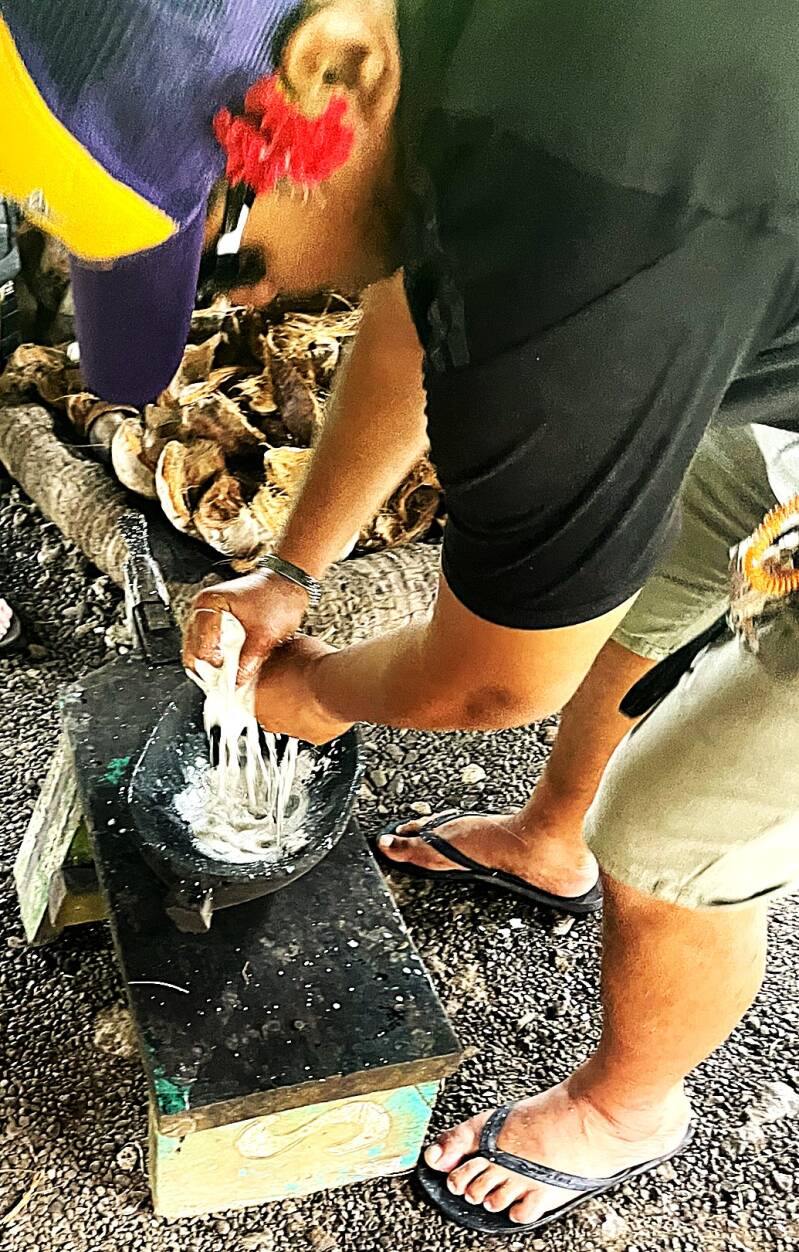
Our first port in Samoa, also known as Western Samoa, was the capital city of Apia. Samoa is made up primarily of two major islands, Upolu and Savai‘i, with a population of approximately 200,000. Apia was on the island of Upolu. Kathie and I splurged and paid for an all-day tour of the island. From top to bottom, left to right - Welcoming dancers, first stop on tour was Piula cave pool, where of course Kathie had to go in the water with the rest of the kids, then further along, enjoying the road scenery and our second stop, Sopoaga Falls sign and waterfall. At the same stop, our guides gave us a demonstration of the many uses of coconuts. Coconuts are the primary agricultural product of many South Pacific islands. We've been told many times that nothing from the coconut tree is ever wasted. After seeing this demonstration, you understand why - starting with dehusking the coconut nut, then scraping the meat from the inside of the nut, then using the sinnet (fibers covering mature coconuts) to squeeze out the coconut oil from the meat.


After the coconut demonstration, we were off again, this time to a "famous" resort that had hosted King Charles and Queen Camilla in October 2024. I didn't see any of the royal family there, so I just had a beer and a delicious grilled fish taco and left for the next adventure. The next stop was Ocean Cavern pool. Since it was a long way down to the water, and we didn't have much time, Kathie had to regretfully opt for a picture-taking option. Next, we headed to our second waterfall of the tour, Togitogiga Falls. You can see from the pictures that the native kids really loved this place. Our third, final, and tallest waterfall of the tour was Papapapaitai Falls. It has a lower falls and an upper falls that towers 300 feet and is a magnificent sight.


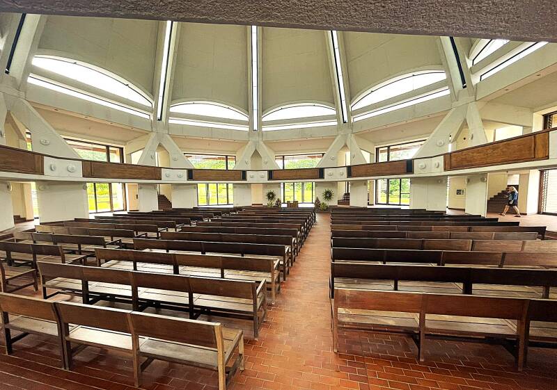
Of course, no tour would be complete without visiting a couple of churches. Our first church was the Baha'i House of Worship. I'll let you Google the Baha'i religion to learn more. But who can tell me what other famous building the shape of this church looks like? A good bottle of wine goes to the winner. Here's the church sign, building, and grounds.


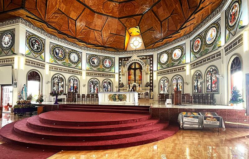
Our second church and final stop on the tour was really magnificent. Right in the center of Apia was the Cathedral of the Immaculate Conception. The original cathedral was built around 1850 and became central to the Catholic religion in Samoa. In 2009, an earthquake badly damaged the cathedral, and it was rebuilt by 2014. Here are pictures of the exterior and interior. Notice the hand-carved wood ceiling....beautiful craftsmanship.


America Samoa will be the last island post on this blog posting. It's culturally and geographically part of the Samoan Islands chain with a population of around 50,000.
We docked in port of Pago Pago, a small city at the end of the Pago Pago deep water harbor. We had our usual greeting of a welcoming sign and dancers. Our first day in port was spent at the US Post Office filling our applications for a second passport. One of the realities of traveling around the world and stopping at 100 countries is you run out of passport pages. So you can do as we did, and file for a second passport so that when the first one runs out of pages you have a second one.


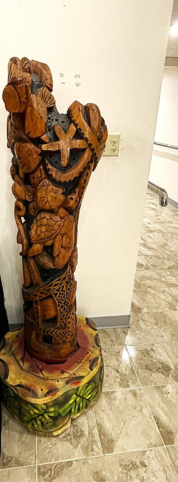
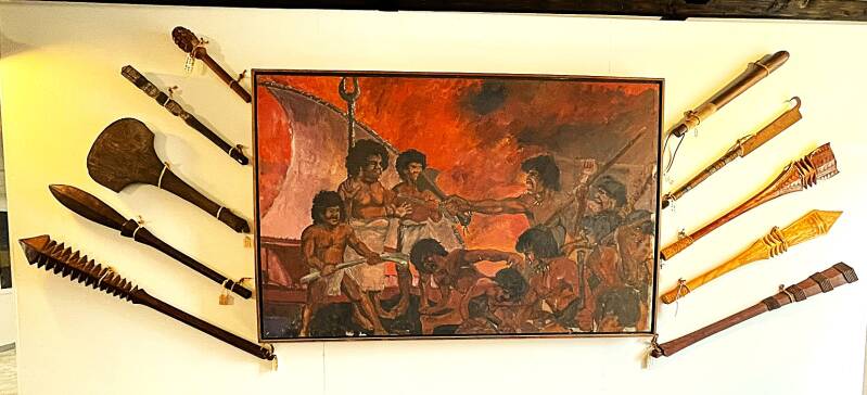
Our second day in port was spent at the local museum where we saw a number of interesting Samoan displays. Many of these had an orientation around wood carving. From top to bottom, left to right - Kava Bowl (Kava comes from grinding the Kava plant and the drink has a cloudy, muddy appearance and an earthy, peppery taste, wood carving before we used computers, a carved tree trunk and a carved canoe and a set of carved battle axes.


For those of you old enough to remember some of the earlier Apollo space flights, here's a picture of astronauts who splashed down in the Pacific and are welcomed into America Samoa.

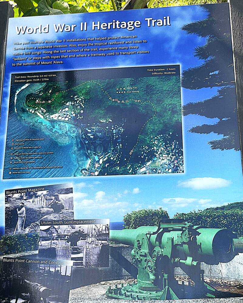
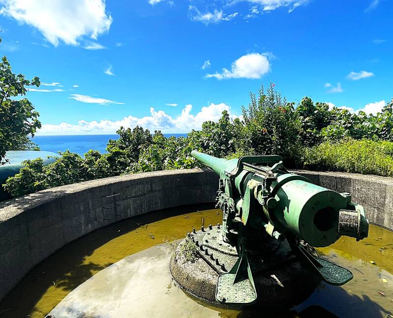
Our third and final day in Pago Pago turned out to be unintentionally exciting and somewhat frightening. First, a little background. At dinner the previous night, our dining partner, Bill, suggested we hike the two-hour WWII Heritage trail. Now Bill has an incredible hiking background, having done the Appalachian and Pacific Crest trails as well as the entire length of South America. Of course, Kathie, the hiking fanatic, was all for it. The day started at 9 AM with a 1/2 hour walk along the coast to the trailhead sign. The sign described the sights we would see, the 1000-foot elevation gain, and the degree of difficulty as moderate. One of these days, I'm going to find the guy who wrote that description and torture him the way I was tortured on the hike :-) The first hour of the hike was fine. We saw the artillery gun placements as we continued along the trail. So I'm thinking that the next hour will be a pleasant hike back down the trail....NOT!!!!! What was supposed to be a less than three-hour hike turned into SIX hours of jungle torture. Our ship was scheduled to leave port at 3 PM that afternoon, and we arrived back at 2:55 PM. Next time I go hiking, I'll do my own research. Regardless, here are a few pictures from the hike.


My next post will start in the French Polynesian islands. Hope you enjoyed this one.
Create Your Own Website With Webador