Japan Part 2 and Taiwan
In this section I'll cover our last six ports in Japan and then I'll move on to the three ports in Taiwan.
Nagasaki is a city of 400,000 on the island of Kyushu, Japan
We had a two-day stay in Nagasaki, but unfortunately, the weather was on the rainy side, so we were limited in our explorations. As I'm sure most of you know, Nagasaki was the site of the second atomic bomb that killed 70,000 people and sealed the fate of Japan. The history of Nagasaki is interesting in that during Japan's period of isolation in the 16th and 17th centuries, Nagasaki was the only gateway to the West that came from Dutch trading partners. After having seen the horrors of the Hiroshima bombing, we decided to skip the Nagasaki bombing site and instead opted for a pleasant place to visit. Glover Garden was a short walk from the ship. It's an open-air museum featuring Western-style residences of 19th-century merchants and great city views. Fortunately, it was spared any damage from the bombings, and most of the buildings are original from the early 1800s. From top to bottom, left to right - Urakami Cathedral on walk to garden, entrance area of Glover Garden, sign describing dock house (dormitory) and dock house, murals and water sculpture, Glover House and bust of Thomas Glover, Japanese garden and outdoor cafe, and finally Nagasaki Harbor and the VVR Odyssey's smoke stack.


Kagoshima is a city of 600,000 on the southern tip of Kyushu.
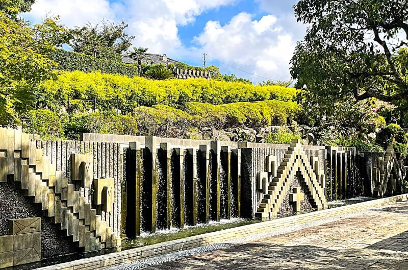
Although we only had one day in Kagoshima, we made the most of it. By the time we were done with our explorations, we had ridden buses, trains, trolleys, and a ferry boat, all while also managing to get in 20,000 steps that day! Kagoshima was a major part of the Meiji Restoration period and was a leading city in Japan's major push towards industrialization. We saw evidence of this and the family that led it when we entered Sengan-en Garden. From top to bottom, left to right - sign explaining the origin of Sangen-en garden, main gate of Sangen-en, sign explaining furnace construction and furnace foundation, sign about deities and deities shrine, lion lantern sign and lion lantern, cat shrine and prayer cards, stove carving sign and stone carving.
After the many sights in Sangen-en Garden, we headed to the waterfront to catch a ferry to Sakurajima, an active volcanic island in Kagoshima Bay. Once off the ferry, we walked up the road a piece to the visitors center. From top to bottom, left to right - ferry boat to Sakurajima, welcome to Sakurajima sign, Torii gate, visitor center artifacts - ash drawing and sign, photo of major 1914 eruption and pumice strata display, and relaxing our tired feet in volcanic water foot bath, and the volcano erupting as we left.
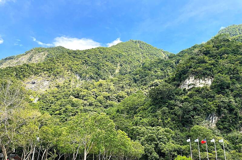
This was a two-day stop, but the first day was a rainy washout. The second was sunny and beautiful, and the ship provided a shuttle to allow us to explore some of the local sights. Although the city center didn't offer much to see, the shuttle took us out to the stunning Nippo Kaigan Quasi-National Park. Here are some pictures from Cape Hyuga & Umagase Viewpoints and then up the hill to the Hososhima Lighthouse that sits 100 m above sea level, where there’s an observatory park around it with coastal views: rugged cliffs, crashing waves, dramatic shoreline.
Amami, often called Amami Ōshima is the largest island in the Amami archipelago, which lies between Kyushu and Okinawa in southern Japan.
t belongs to Kagoshima Prefecture and is part of the Ryukyu Islands chain, though culturally and historically it has its own identity. Amami city has a population of 40,000, while the entire island's population is just 60,000. On our first day on the island, we had a short walk away from the pier to the Amami City Museum. As with most of the museums in Japan, the entrance for those over 65 is either free or at most two dollars per person. Another great thing about the museums is that they are air-conditioned, which was important when the usual temperature was 95 degrees with 90% humidity. In the museum lobby, we were immediately greeted with replicas of the native fishing and ocean-going vessels. Further along in the museum there are many signs and displays related to the history of Amami.


Our second day on Amami was our discovery day. With our good friends Jeff and Susan, we rented a car and headed out for a tour of the island, which is basically full of mountains, valleys and shoreline. From top to bottom, left to right - coastline view and one of the many tunnels that allow you to drive along the coastline, cliff sign and ocean cave, mountain viewpoint out to the ocean, Materiya waterfall sign and waterfall, Funangyo falls and sign and warning, a few other interesting sights along the way - Banyan tree growing on a rock, world's largest legume sign (get your google translate out) and lastly another group of local people celebrating our departure :-)


Okinawa, our next stop, is the biggest of the Ryukyu Islands and is about 70 miles long with a population of 1.5 million people.
We docked in the capital city of Naha, which has a population of about 320,000 people. Day one in Naha was a shopping day, so not much to see, but a lot of buildings and even more people. After all of these ports and cities, I've come to the conclusion that Japanese people love to shop and they do it all day long, every day of the week. Day two was our day to get out and do our now infamous city tour. This one started with a thud. After trying to find a bus to the palace gardens without any luck, we ended up taking an expensive taxi ride instead. As we got out of the taxi, my keen eye told me something was wrong because there wasn't a single car in the parking lot....you guessed it, the palace garden was closed on Wednesday. My city tour planning guide, Kathie, was a bit embarrassed, but that's the way it goes. She promised the next stop tour would be open. So off we went, heading toward Shurito Castle. First, we walked straight downhill and then straight uphill. Along the way downhill, we passed an interesting and elaborate cemetery. Then on the uphill route, we took the "Old Stone Road". Next to the sign and the road was a long-abandoned communal water hole and a very attractive shrine.


We finally arrived at the high point of the trip (and I mean that literally and figuratively) - Shurito Castle. From top to bottom, left to right - sign explaining Shurito Castle history, picture of the Castle grounds, details of each building, the main entrance gate and castle wall, religious practices at the castle, and a few views from the top. Unfortunately, the main hall is still being restored, so not much detail to see.


Ishigaki island was our last and final stop in Japan. This is after 1332 nautical miles, 14 ports and 17 cities.
Since this was just a one-day stop at this relatively small island, we limited ourselves to a couple of exciting bus rides out to a snorkeling location and then back. Here are a few sights on the way to the beach - Papaya trees, ubiquitous beverage vending machine, screw pine tree, and then the "crowded" snorkeling beach.


The next country in our around the world journey was Taiwan. Taiwan is 112 miles off the southeastern coast of China, its 240 miles long and 90 miles wide, about the size of Maryland. It is very mountainous with over 100 peaks that are at least 10,000 feet in elevation. Its total population is 23 million and the capital is Taipei. Our first stop was two days in the city of Haulien on the southeast coast of Taiwan.
With a population of 100,000, it's not a huge city, so our first day was a walking tour of the city center. As with many of our ports, we often have an entertaining welcoming committee. Here's the one we had in Haulien. Then, looking beyond the port, here's a view from our balcony of the mountains in the distance and one of an interesting building in the city center.


The highlight of our stay in Hualien occurred on the second day when we grabbed a HOHO (hop on, hop off) bus and headed north out of town. This was a $4 all-day, 24-stop tour along the coastline that ended at Taroko National Park. To be honest, most of the sights along the way, except for a huge beach area, were not worth a stop. But the views and landscape of our final destination certainly made the trip worthwhile. The main attraction at Taroko National Park is a very long gorge created by the Liwu River, which runs through the gorge and out to the Pacific Ocean. The park was recently famous for a very unfortunate event, a 7.3 earthquake less than a year ago. From top to bottom, left to right - HOHO route map, indigenous people map, bridge over river in gorge, alluvial fan Liwu river and Pacific Ocean, a few pictures of the gorge cliffs, trail sign for many of the hiking paths throughout the gorge before the earthquake, signs describing the earthquake, earthquake restoration work, and the beauty of the gorge.


Our next stop was the port of Keelung with a population of 360,000 and located on the northeaster tip of Taiwan facing the Pacific ocean.
Keelung is also the gateway city to Taipei, the capital of Taiwan. We were in Keelung for three days, but took the opportunity on the second day to take a train to Taipei. Day one in Keelung was spent exploring the city, which was conveniently located very close to the port. From top to bottom, left to right - Keelung city sign and VVR Odyssey in port, harbor promenade in daytime and maritime harbor sculpture, view of old town and new town skyscraper, Kathie at the Maritime museum, pictures of Chinese temple, temple protectors and inside temple, harbor promenade at night on the way to the night market.


On the third day in Keelung, our curiosity got the best of us after looking out across the harbor at a 3 level structure on a hill. So off we went early in the morning to find this structure, which, as it turns out, was actually a park in honor of Chiang Kai-shek, the authoritarian ruler of Taiwan from 1949 to 1975. From top to bottom, left to right - Kathie heading up the first flight, Park sign, gate at level one, umbrella entrance to level three, level three temple (actually a false front), detailed figurines in false front, famous laughing Buddha, temple on the way down, and Kathie with her Keelung guide.


Day two in the Keelung port allowed us to take a 45-minute train ride to Taipei, the capital of Taiwan, with a population of 2 million people.
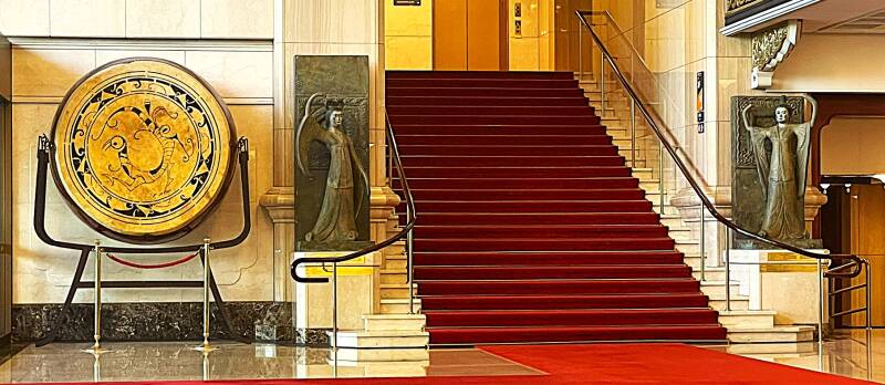
While we didn't get to see many sights, we sure got to see a lot of the Taipei subway system as we moved around the city. The highlight of the trip was a stop at the Chiang Kai-shek Memorial Hall. From left to right, there are four prominent structures in this compound: The entry gate, the National Concert Hall, the National Theater, and the Memorial. As we ascended the steps to the National Theater, we were met by a young staff member who wanted us to know that since we were elderly :-) Admission was free, and they gave us an audio guide to enjoy all the aspects and artifacts of both the concert hall and the theater. Inside both of these facilities, there were a total of four amazing vertical flower gardens. These are living plants growing through a cloth mess background that are being watered behind the mess. Here are two of the flower gardens. As we wandered around both facilities, listening to our audio guide, we encountered several interesting artifacts. From top to bottom, left to right - lobby in theater and concert hall, 97-key grand piano and sign, a fresco in the concert all that took two years to complete, and a repurposed set of stage flooring honoring Charlie Chaplin's visit to the facility.


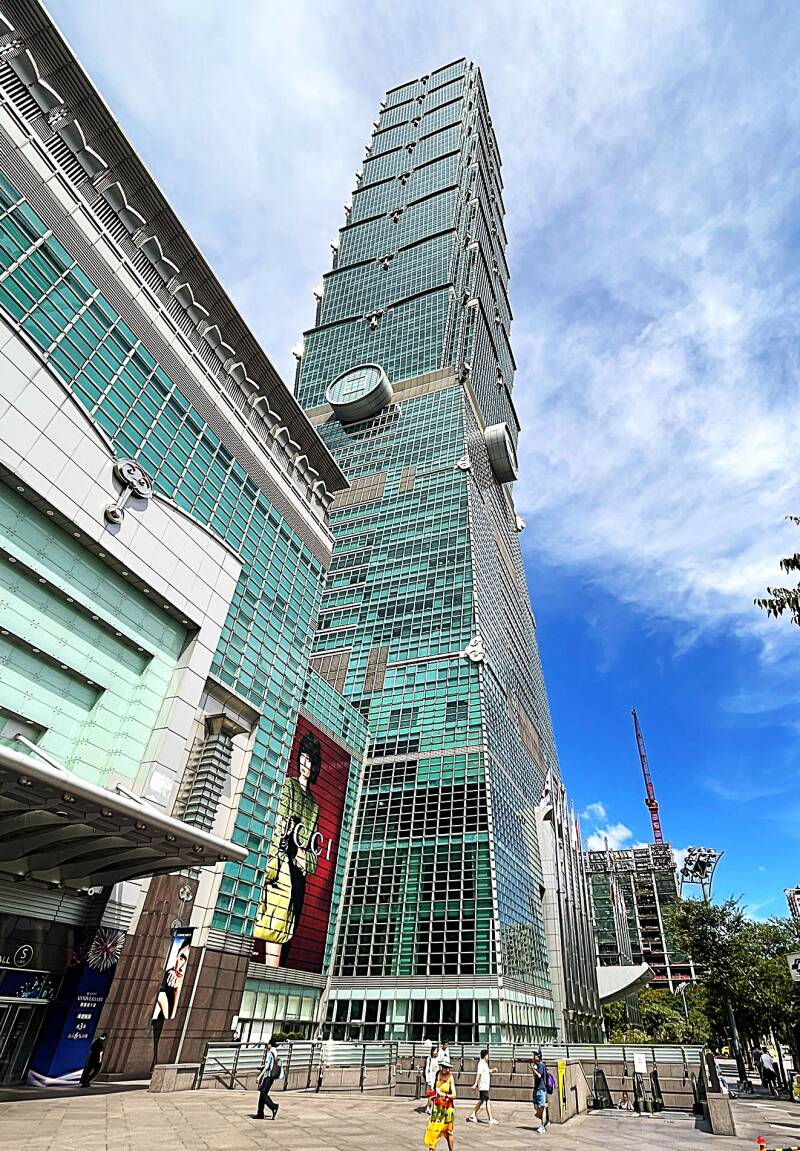
Our last stop in Taipei was Taipei 101, which at one time was the tallest building in the world. Here's a picture from a distance and then a close-up.

Our final port and city in Taiwan was Tainan, which is located on the southwestern tip of Taiwan across the Taiwan Strait from mainland China.
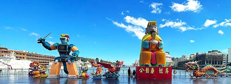
It is considered Taiwan's oldest city and is quite large, with a population of almost 2 million people. Even though we were scheduled to spend two full days there, we actually had to leave by 11 AM the second day to sail ahead of Typhoon Ragasa. The one good day we had in Tainan was well spent visiting the Tainan city museum and the many temples located throughout the city. Before arriving at the city museum, we were entertained with a drum corps at the pier. Then, on the way to the museum, we were greeted with a very modern piece of sculpture.


Here are a few pictures from inside the city museum. From top to bottom, left to right - abstract sculpture of Koxinga aka Zheng Chenggog and explanation sign. If there's one thing you can be sure of in Taiwan, if there is a famous historical person they are going to have a least two names if not more. Next up is a sign detailing part of Tainan history, then another sign and picture of a Koxinga buddy - Chang Wan-Li. Lastly a display of historical Chinese robe.


Literally next door to the museum we found a park and temple dedicated to that famous guy Koxinga. First up is a sign and a very big statue of the man himself on his trusty horse Giddy Up (just kidding). Next up and next door is archway sign and archway to Koxinga temple and then the temple.


As if you haven't already seen another pictures of temples, shrines et al, here's a few more as we wandered the streets of Tainan.


That's all for Taiwan for now. We have to get out of town to avoid a direct hit from Typhoon Ragasa as we steam toward our next country the Philippines.
Create Your Own Website With Webador